
Slow Streets
Consultation has concluded

To help residents physically distance and mitigate the risk of COVID-19 to our communities, we are re-shaping how we use our streets and public spaces.
Slow Streets provide opportunities for walking, cycling and rolling and make it easier for people to exercise and access businesses in their neighbourhoods.
Slow Streets have been planned on residential/local streets based on several factors, including traffic volumes, signalized crossings at busier streets, equity and access to green space, nearby parks, and community amenities.
What is happening?
- Since May 2020 we have installed 40 km of Slow Streets with simple traffic barriers and signs.
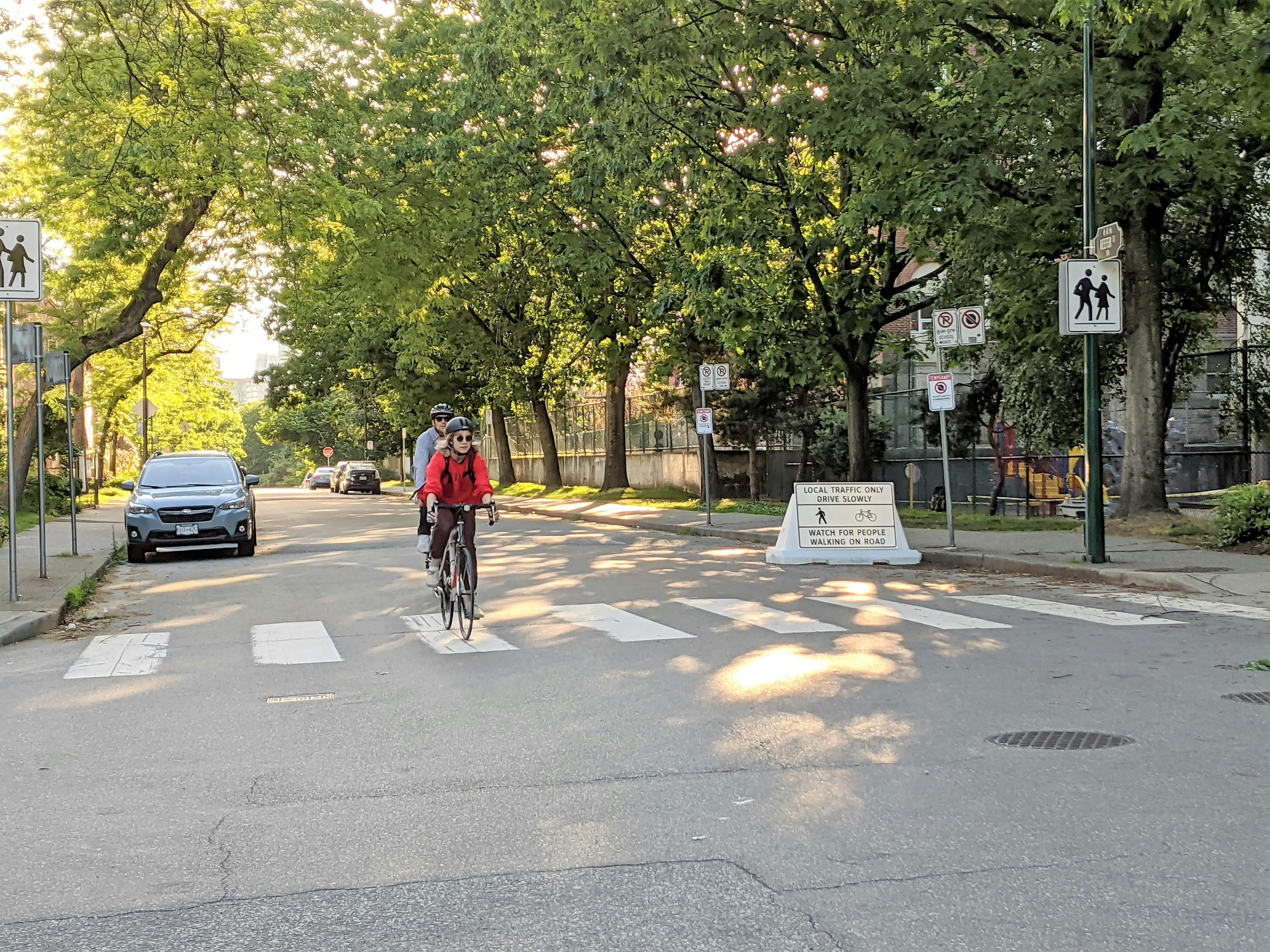
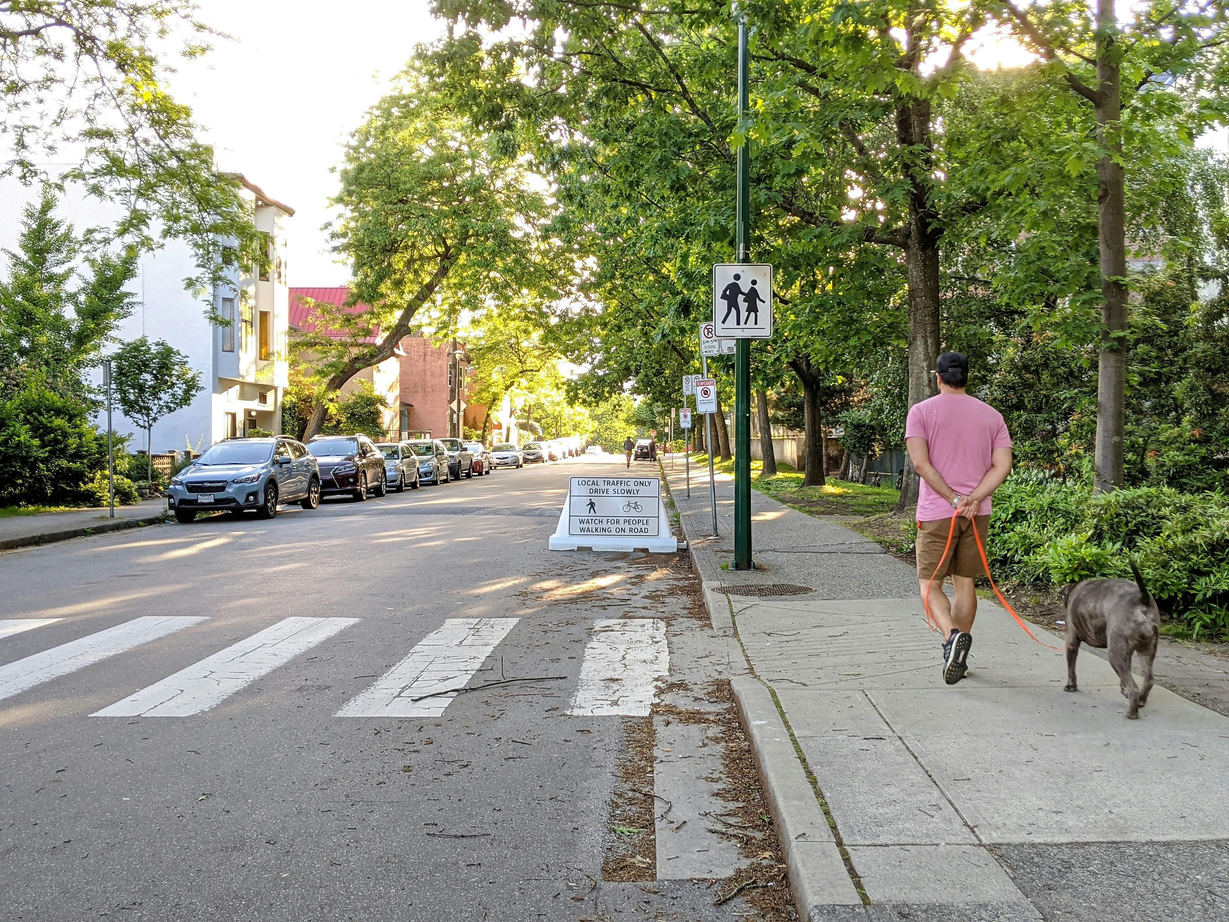
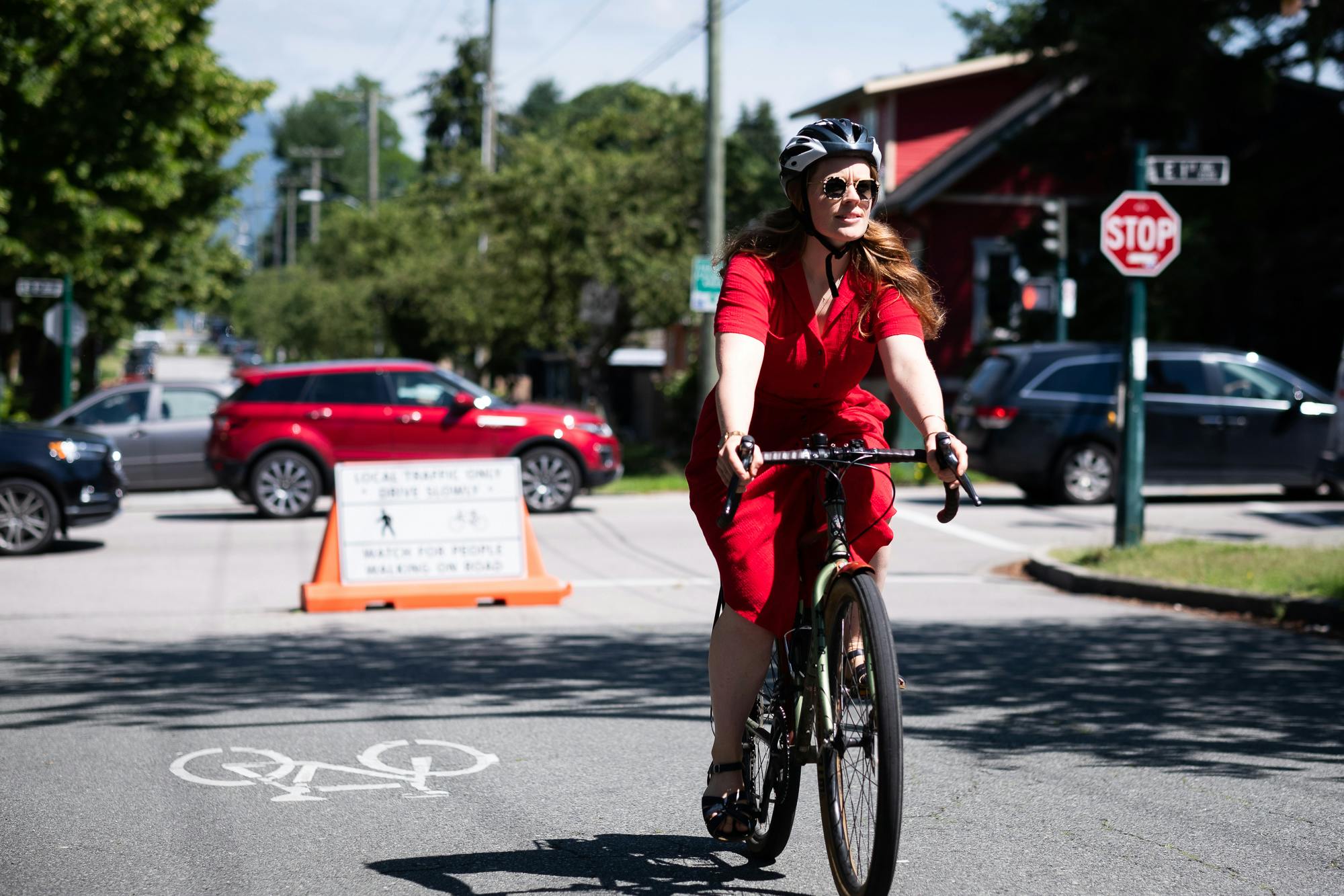
- This fall, we are implementing temporary traffic calming measures on selected Slow Streets to help reduce motor vehicle volumes and make these routes more comfortable for walking, cycling and rolling.
- As part of the Slow Streets Upgrades, additional signage and concrete barriers will be installed and there will be some local changes to parking and traffic circulation.
- We're asking for your feedback about how these changes are working.
Slow Streets - Supplemental Design Guide (PDF)
- This guide provides details about each traffic calming measure and the rationale behind the transportation upgrade.
- The Slow Streets Team will regularly update this guide with detailed information about upcoming Slow Streets upgrades.
Next steps
- Using input from residents and businesses, we’ll make adjustments at key locations this fall.
- Your input will help us make adjustments and inform longer-term opportunities for these routes.
- We will continue to monitor Slow Streets and anticipate that other routes and traffic calming upgrades will be in place through 2021.
To help residents physically distance and mitigate the risk of COVID-19 to our communities, we are re-shaping how we use our streets and public spaces.
Slow Streets provide opportunities for walking, cycling and rolling and make it easier for people to exercise and access businesses in their neighbourhoods.
Slow Streets have been planned on residential/local streets based on several factors, including traffic volumes, signalized crossings at busier streets, equity and access to green space, nearby parks, and community amenities.
What is happening?
- Since May 2020 we have installed 40 km of Slow Streets with simple traffic barriers and signs.
- This fall, we are implementing temporary traffic calming measures on selected Slow Streets to help reduce motor vehicle volumes and make these routes more comfortable for walking, cycling and rolling.
- As part of the Slow Streets Upgrades, additional signage and concrete barriers will be installed and there will be some local changes to parking and traffic circulation.
- We're asking for your feedback about how these changes are working.
Slow Streets - Supplemental Design Guide (PDF)
- This guide provides details about each traffic calming measure and the rationale behind the transportation upgrade.
- The Slow Streets Team will regularly update this guide with detailed information about upcoming Slow Streets upgrades.
Next steps
- Using input from residents and businesses, we’ll make adjustments at key locations this fall.
- Your input will help us make adjustments and inform longer-term opportunities for these routes.
- We will continue to monitor Slow Streets and anticipate that other routes and traffic calming upgrades will be in place through 2021.
-
New Traffic Calming Upgrades at Fir Street and W7th Avenue and along Glen Drive
Share New Traffic Calming Upgrades at Fir Street and W7th Avenue and along Glen Drive on Facebook Share New Traffic Calming Upgrades at Fir Street and W7th Avenue and along Glen Drive on X (formerly Twitter) Share New Traffic Calming Upgrades at Fir Street and W7th Avenue and along Glen Drive on Linkedin Email New Traffic Calming Upgrades at Fir Street and W7th Avenue and along Glen Drive linkThis spring, we are implementing temporary traffic calming measures on selected Slow Streets. Traffic calming measures help reduce motor vehicle volumes and make these routes more comfortable for walking, cycling and rolling.
As part of the Slow Streets Upgrades, additional signage and concrete diverters will be installed and there will be some local changes to parking and traffic circulation. Over the next few weeks, we will install traffic calming measures on two Slow Streets:
- Fir Street at W 7th Avenue: To help reduce motor vehicle volumes along the 7th Avenue bikeway, we will install temporary diverters for motor vehicles traveling on W 7th Avenue. Motor vehicles will not be able to travel straight through W 7th Avenue. These traffic diverters will provide adequate space for people cycling and walking on W 7th Avenue to turn and travel through.
- Glen Drive at E Broadway and E 12th Avenue: To reduce motor vehicle shortcutting, we will install traffic diverters that will restrict turns for motor vehicles turning south from Broadway to Glen Drive or north from 12th Avenue to Glen Drive. These traffic diverters will provide adequate space for people cycling and walking on Glen Drive to travel through the intersection safely. These upgrades will encourage people driving to use arterial streets such as E Broadway, Clark Drive, Great Northern Way and E 12th Avenue as much as possible, and minimize traffic using local streets to access destinations like Vancouver Community College.
A notification letter has been sent to the local residents and businesses providing details of the upgrades and information on on-going engagement. You can also review the notification letters in the Documents folder and the updated Supplemental Design Guide (PDF) to learn more about each traffic calming measure and the rationale behind the upgrade.
Please fill out an online traffic calming upgrades survey and share your feedback about how these changes are working. We will monitor these traffic calming measures by reviewing public feedback, collecting data and making adjustments as needed.
Consultation has concludedThis spring, we are implementing temporary traffic calming measures on selected Slow Streets. Traffic calming measures help reduce motor vehicle volumes and make these routes more comfortable for walking, cycling and rolling.
As part of the Slow Streets Upgrades, additional signage and concrete diverters will be installed and there will be some local changes to parking and traffic circulation. Over the next few weeks, we will install traffic calming measures on two Slow Streets:
- Fir Street at W 7th Avenue: To help reduce motor vehicle volumes along the 7th Avenue bikeway, we will install temporary diverters for motor vehicles traveling on W 7th Avenue. Motor vehicles will not be able to travel straight through W 7th Avenue. These traffic diverters will provide adequate space for people cycling and walking on W 7th Avenue to turn and travel through.
- Glen Drive at E Broadway and E 12th Avenue: To reduce motor vehicle shortcutting, we will install traffic diverters that will restrict turns for motor vehicles turning south from Broadway to Glen Drive or north from 12th Avenue to Glen Drive. These traffic diverters will provide adequate space for people cycling and walking on Glen Drive to travel through the intersection safely. These upgrades will encourage people driving to use arterial streets such as E Broadway, Clark Drive, Great Northern Way and E 12th Avenue as much as possible, and minimize traffic using local streets to access destinations like Vancouver Community College.
A notification letter has been sent to the local residents and businesses providing details of the upgrades and information on on-going engagement. You can also review the notification letters in the Documents folder and the updated Supplemental Design Guide (PDF) to learn more about each traffic calming measure and the rationale behind the upgrade.
Please fill out an online traffic calming upgrades survey and share your feedback about how these changes are working. We will monitor these traffic calming measures by reviewing public feedback, collecting data and making adjustments as needed.
-
Step One Engagement Summary
Share Step One Engagement Summary on Facebook Share Step One Engagement Summary on X (formerly Twitter) Share Step One Engagement Summary on Linkedin Email Step One Engagement Summary linkThe Step One Engagement Summary is out!
Since we began implementing Slow Streets in Spring 2020 as COVID-19 response initiative, we have been gathering feedback through email, 311 and the VanConnect app.
Additionally, between August and October 2020, we heard your thoughts about this initiative through an online feedback survey. We have received a over 1,900 responses and overall, Slow Streets have a high level of support with more than 70% of survey participants ‘Liking or Really Liking the initiative. Reviewing your feedback has given us a broad understanding of who is using Slow Streets, how often, and the modes of travel people are taking along Slow Streets.
A number of suggestions were made to improve the program including additional traffic calming measures to lower motor vehicle volumes (70% of participants supported), and lowering motor vehicle speeds (75% of participants supported). The main concerns that survey participants reported while using Slow Streets were non-local traffic using the street (41% of participants), higher motor vehicle speeds (30% of participants) and damaged/missing signs and barriers (26% of participants).
Thank you to everyone that provided feedback.
Click here(External link) to view the Step One Engagement Summary (PDF).
You can also review the Supplemental Design Guide (PDF)(External link) to learn more about each traffic calming measure.
We continue to gather feedback about the temporary traffic calming upgrades. Please fill out the Slow Streets – Traffic Calming Upgrades online survey and share your feedback about how these changes are working. We are monitoring these traffic calming measures by reviewing public feedback, collecting data and making adjustments as needed.
Consultation has concludedThe Step One Engagement Summary is out!
Since we began implementing Slow Streets in Spring 2020 as COVID-19 response initiative, we have been gathering feedback through email, 311 and the VanConnect app.
Additionally, between August and October 2020, we heard your thoughts about this initiative through an online feedback survey. We have received a over 1,900 responses and overall, Slow Streets have a high level of support with more than 70% of survey participants ‘Liking or Really Liking the initiative. Reviewing your feedback has given us a broad understanding of who is using Slow Streets, how often, and the modes of travel people are taking along Slow Streets.
A number of suggestions were made to improve the program including additional traffic calming measures to lower motor vehicle volumes (70% of participants supported), and lowering motor vehicle speeds (75% of participants supported). The main concerns that survey participants reported while using Slow Streets were non-local traffic using the street (41% of participants), higher motor vehicle speeds (30% of participants) and damaged/missing signs and barriers (26% of participants).
Thank you to everyone that provided feedback.
Click here(External link) to view the Step One Engagement Summary (PDF).
You can also review the Supplemental Design Guide (PDF)(External link) to learn more about each traffic calming measure.
We continue to gather feedback about the temporary traffic calming upgrades. Please fill out the Slow Streets – Traffic Calming Upgrades online survey and share your feedback about how these changes are working. We are monitoring these traffic calming measures by reviewing public feedback, collecting data and making adjustments as needed.
-
Traffic calming measures along Charles and Heather streets!
Share Traffic calming measures along Charles and Heather streets! on Facebook Share Traffic calming measures along Charles and Heather streets! on X (formerly Twitter) Share Traffic calming measures along Charles and Heather streets! on Linkedin Email Traffic calming measures along Charles and Heather streets! linkThis fall, we are implementing temporary traffic calming measures on selected Slow Streets. Traffic calming measures help reduce motor vehicle volumes and make these routes more comfortable for walking, cycling and rolling.
As part of the Slow Streets Upgrades, additional signage and concrete barriers will be installed and there will be some local changes to parking and traffic circulation. Over the next few weeks, we will install traffic calming measures on two Slow Streets:
- Heather Street at W 14th Avenue: To help reduce motor vehicle volumes along Heather Street, we are installing a temporary full closure for motor vehicles north of 14th Avenue.
- Charles Street between Kamloops and Slocan streets: To limit short cutting through the neighbourhood, we will install diverters and convert Charles St to one way westbound between Kamploops and Slocan streets while still allowing residents to circulate and park on Charles Street.
A notification letter will be sent to the local residents and businesses providing details of the upgrades and information on on-going engagement. You can also review the Supplemental Design Guide (PDF) to learn more about each traffic calming measure and the rationale behind the transportation upgrade. We will regularly update this guide and the Slow Streets Map with Traffic Calming Upgrades locations.
Please fill out an online survey and share your feedback about how these changes are working. We will monitor these traffic calming measures by reviewing public feedback, collecting data and making adjustments as needed.
Consultation has concludedThis fall, we are implementing temporary traffic calming measures on selected Slow Streets. Traffic calming measures help reduce motor vehicle volumes and make these routes more comfortable for walking, cycling and rolling.
As part of the Slow Streets Upgrades, additional signage and concrete barriers will be installed and there will be some local changes to parking and traffic circulation. Over the next few weeks, we will install traffic calming measures on two Slow Streets:
- Heather Street at W 14th Avenue: To help reduce motor vehicle volumes along Heather Street, we are installing a temporary full closure for motor vehicles north of 14th Avenue.
- Charles Street between Kamloops and Slocan streets: To limit short cutting through the neighbourhood, we will install diverters and convert Charles St to one way westbound between Kamploops and Slocan streets while still allowing residents to circulate and park on Charles Street.
A notification letter will be sent to the local residents and businesses providing details of the upgrades and information on on-going engagement. You can also review the Supplemental Design Guide (PDF) to learn more about each traffic calming measure and the rationale behind the transportation upgrade. We will regularly update this guide and the Slow Streets Map with Traffic Calming Upgrades locations.
Please fill out an online survey and share your feedback about how these changes are working. We will monitor these traffic calming measures by reviewing public feedback, collecting data and making adjustments as needed.
-
Removal of temporary vehicle closure (concrete barriers) on Wall Street near Oxford and Cambridge parks
Share Removal of temporary vehicle closure (concrete barriers) on Wall Street near Oxford and Cambridge parks on Facebook Share Removal of temporary vehicle closure (concrete barriers) on Wall Street near Oxford and Cambridge parks on X (formerly Twitter) Share Removal of temporary vehicle closure (concrete barriers) on Wall Street near Oxford and Cambridge parks on Linkedin Email Removal of temporary vehicle closure (concrete barriers) on Wall Street near Oxford and Cambridge parks linkIn September 2020, temporary traffic calming measures were installed on Wall St near Oxford and Cambridge Parks to improve comfort for people walking, cycling and rolling. This full closure used concrete barriers to prevent motor vehicles from short-cutting along the street.
We’ve been tracking and reviewing public feedback about the Slow Streets initiative and the recent traffic calming measures through e-mails, 3-1-1, social media and an online public survey. We want to thank everyone who has provided feedback about the changes and the implementation process.
To address the concerns about the impact of the changes, we will remove the temporaryContinue reading
Consultation has concludedIn September 2020, temporary traffic calming measures were installed on Wall St near Oxford and Cambridge Parks to improve comfort for people walking, cycling and rolling. This full closure used concrete barriers to prevent motor vehicles from short-cutting along the street.
We’ve been tracking and reviewing public feedback about the Slow Streets initiative and the recent traffic calming measures through e-mails, 3-1-1, social media and an online public survey. We want to thank everyone who has provided feedback about the changes and the implementation process.
To address the concerns about the impact of the changes, we will remove the temporary closure in November 2020 until staff can return to have additional conversations about mobility in the neighbourhood.
Over the long term, Wall Street has been identified as part of the Portside Greenway. Greenways enhance the experience of walking and cycling around the city and are designed to be comfortable for all ages and abilities. They include improvements like expanded parks, increased landscaping, public art, and drinking fountains. The Portside Greenway will be developed in stages with a number of opportunities for public consultation.
Click here to view Supplemental design guide explaining design details of the temporary vehicle closure.
Click here to read the notification letter explaining the removal of temporary vehicle closure.
-
Traffic Calming Measures coming to selected Slow Streets!
Share Traffic Calming Measures coming to selected Slow Streets! on Facebook Share Traffic Calming Measures coming to selected Slow Streets! on X (formerly Twitter) Share Traffic Calming Measures coming to selected Slow Streets! on Linkedin Email Traffic Calming Measures coming to selected Slow Streets! linkSince May, we've designated 40km of Slow Streets with simple traffic barriers and signs to make it easier for residents to exercise and access businesses in their local neighbourhood.
This fall, we are implementing temporary traffic calming measures on selected Slow Streets. Traffic calming measures help reduce motor vehicle volumes and make these routes more comfortable for walking, cycling and rolling.
As part of the Slow Streets Upgrades, additional signage and concrete barriers will be installed and there will be some local changes to parking and traffic circulation. This week, we will install traffic calming measures on two Slow Streets:
Consultation has concludedSince May, we've designated 40km of Slow Streets with simple traffic barriers and signs to make it easier for residents to exercise and access businesses in their local neighbourhood.
This fall, we are implementing temporary traffic calming measures on selected Slow Streets. Traffic calming measures help reduce motor vehicle volumes and make these routes more comfortable for walking, cycling and rolling.
As part of the Slow Streets Upgrades, additional signage and concrete barriers will be installed and there will be some local changes to parking and traffic circulation. This week, we will install traffic calming measures on two Slow Streets:
- Wall Street near Oxford and Cambridge Park
- Ontario Street near Riley Park
Review the Supplemental Design Guide to learn more about each traffic calming measure and the rationale behind the transportation upgrade. We will regularly update this guide and the Slow Streets Map with Traffic Calming Upgrades locations.
Once the measures are installed, we will be asking the public to share their feedback about how these changes are working. We will monitor these traffic calming measures by reviewing public feedback, collecting data and making adjustments as needed.
The planned upgrades align with upcoming and long-term transportation projects such as existing and future greenways, bike lanes, and traffic calming measures.
-
Wave 5 | August 7 | 10 km
Share Wave 5 | August 7 | 10 km on Facebook Share Wave 5 | August 7 | 10 km on X (formerly Twitter) Share Wave 5 | August 7 | 10 km on Linkedin Email Wave 5 | August 7 | 10 km linkLast week, our crew installed the latest wave of #SlowStreets.
We’ve designated 40 km of Vancouver’s roads for Slow Streets to give people more room to move. With Slow Streets open to local traffic only, they’re a great place to get some exercise or enjoy the fresh air while staying two metres apart. Have you had a chance to try one out?
- Woodland Drive from Charles Street to E 15th Avenue
- E 15th Avenue/ E 14 Avenue/ E 13th Avenue from Woodland Drive to St. George Street
- St. George Street from E 8th Avenue to E 13th Avenue and EContinue reading
Consultation has concludedLast week, our crew installed the latest wave of #SlowStreets.
We’ve designated 40 km of Vancouver’s roads for Slow Streets to give people more room to move. With Slow Streets open to local traffic only, they’re a great place to get some exercise or enjoy the fresh air while staying two metres apart. Have you had a chance to try one out?
- Woodland Drive from Charles Street to E 15th Avenue
- E 15th Avenue/ E 14 Avenue/ E 13th Avenue from Woodland Drive to St. George Street
- St. George Street from E 8th Avenue to E 13th Avenue and E 27th to E 31st Avenue
- E 8th Avenue from St. George Street to Glen Drive
- Glen Drive/ Windsor Street from E 8th Avenue to E 27th Avenue
- E 27th Avenue from Windsor Street via pop-up plaza to St. George Street
- E 31st Avenue/ E 30th Avenue from Ontario Street to St. George Street
- Ontario Street from E 30th Avenue to E 33rd Avenue
These routes link to one of the pop-up plaza at E 27th Avenue and Fraser Street. Other installed routes provide connection to plazas at W 18th Avenue and Cambie Street and W 13th Avenue and Granville Street. Check out more about plazas at vancouver.ca/pop-up-plazas.
If you are sharing any photos of your discoveries about Slow Streets on social media, please tag us using #SlowStreetsVan and #WalkBikeRoll.
-
Wave 4 | June 21 | 5 km
Share Wave 4 | June 21 | 5 km on Facebook Share Wave 4 | June 21 | 5 km on X (formerly Twitter) Share Wave 4 | June 21 | 5 km on Linkedin Email Wave 4 | June 21 | 5 km linkThe next set of Slow Streets routes are:
- W 14th Avenue from Main Street to Alder Street
- W 18th Avenue from Main Street to Heather Street
- W 13th Avenue from Alder Street to Granville Street (which connects to a pop-up plaza at W 13th Avenue and Granville Street)
- Alder Street from W 14th Avenue to W 7th Avenue
- W 7th Avenue from Alder Street to Laurel Street
- Heather St from W 22nd Avenue to W 14th Avenue
If you are driving, remember that these streets are now for local access only, and watch for people who may be walking onContinue reading
Consultation has concludedThe next set of Slow Streets routes are:
- W 14th Avenue from Main Street to Alder Street
- W 18th Avenue from Main Street to Heather Street
- W 13th Avenue from Alder Street to Granville Street (which connects to a pop-up plaza at W 13th Avenue and Granville Street)
- Alder Street from W 14th Avenue to W 7th Avenue
- W 7th Avenue from Alder Street to Laurel Street
- Heather St from W 22nd Avenue to W 14th Avenue
If you are driving, remember that these streets are now for local access only, and watch for people who may be walking on the street. Be courteous, drive slow, and please don't pass people walking and cycling on #SlowStreets!
If you are sharing any photos of your discoveries on social media, please tag us using #SlowStreetsVan and #WalkBikeRoll.
-
Wave 3 | June 5 | 4 km
Share Wave 3 | June 5 | 4 km on Facebook Share Wave 3 | June 5 | 4 km on X (formerly Twitter) Share Wave 3 | June 5 | 4 km on Linkedin Email Wave 3 | June 5 | 4 km linkOver the weekend, crews were busy installing the next round of Slow Streets! You can expect to see new barriers and signage:
- Charles Street from McLean Drive to Slocan Street
- Kitchener Street from Slocan Street to Lilooet Street
- Lilooet Street from Hastings Park to Sunrise Park
With all of the new people cycling and rolling on the streets these days, please remember to #bekind as people learn and develop confidence while riding. Practice #physicaldistancing and avoid crowded areas, and if you can, try traveling outside of peak hours. Remember, if you are driving, Slow Streets are for local traffic onlyContinue reading
Consultation has concludedOver the weekend, crews were busy installing the next round of Slow Streets! You can expect to see new barriers and signage:
- Charles Street from McLean Drive to Slocan Street
- Kitchener Street from Slocan Street to Lilooet Street
- Lilooet Street from Hastings Park to Sunrise Park
With all of the new people cycling and rolling on the streets these days, please remember to #bekind as people learn and develop confidence while riding. Practice #physicaldistancing and avoid crowded areas, and if you can, try traveling outside of peak hours. Remember, if you are driving, Slow Streets are for local traffic only. Keep speeds low, and please watch for people walking, cycling, playing or otherwise enjoying the roadway.
If you are sharing any photos of your discoveries on social media, please tag us using #SlowStreetsVan and #WalkBikeRoll.
-
Wave 2 | May 29 | 7 km
Share Wave 2 | May 29 | 7 km on Facebook Share Wave 2 | May 29 | 7 km on X (formerly Twitter) Share Wave 2 | May 29 | 7 km on Linkedin Email Wave 2 | May 29 | 7 km linkFour more routes were installed in the month of May, providing shared space for people walking, cycling, rolling and driving while maintaining safe physical distance.
- Keefer Street from Gore Avenue to Campbell Avenue
- Princess Avenue from Keefer Street to Atlantic Street
- Windsor Street from E 37th Avenue to E 41st Avenue
- Inverness Street from E 41st Avenue to E 51st Avenue
- E 51st Avenue from Inverness Street to Ontario Street
If you are sharing any photos of your discoveries on social media, please tag us using #SlowStreetsVan and #WalkBikeRoll.Consultation has concludedFour more routes were installed in the month of May, providing shared space for people walking, cycling, rolling and driving while maintaining safe physical distance.
- Keefer Street from Gore Avenue to Campbell Avenue
- Princess Avenue from Keefer Street to Atlantic Street
- Windsor Street from E 37th Avenue to E 41st Avenue
- Inverness Street from E 41st Avenue to E 51st Avenue
- E 51st Avenue from Inverness Street to Ontario Street
If you are sharing any photos of your discoveries on social media, please tag us using #SlowStreetsVan and #WalkBikeRoll. -
Wave 1 | May 22 | 12 km
Share Wave 1 | May 22 | 12 km on Facebook Share Wave 1 | May 22 | 12 km on X (formerly Twitter) Share Wave 1 | May 22 | 12 km on Linkedin Email Wave 1 | May 22 | 12 km linkIn the third week of May, we rolled out our first wave of Slow Streets routes:
- Wall Street
- Lakewood Drive
- Gladstone Street from Vanness Avenue to E 36th Avenue
- E 36th Avenue from Gladstone Street to Dumfries Street
- E 37th Avenue from Dumfries Street to Cambie Street
These are priority streets for walking and cycling, and we invite vehicle drivers for local traffic only. Please watch for people who may be walking or cycling in the street, keep speeds low, and be kind.
If you are sharing any photos of your discoveries on social media, please tag us using #SlowStreetsVan and #WalkBikeRoll.Consultation has concludedIn the third week of May, we rolled out our first wave of Slow Streets routes:
- Wall Street
- Lakewood Drive
- Gladstone Street from Vanness Avenue to E 36th Avenue
- E 36th Avenue from Gladstone Street to Dumfries Street
- E 37th Avenue from Dumfries Street to Cambie Street
These are priority streets for walking and cycling, and we invite vehicle drivers for local traffic only. Please watch for people who may be walking or cycling in the street, keep speeds low, and be kind.
If you are sharing any photos of your discoveries on social media, please tag us using #SlowStreetsVan and #WalkBikeRoll.
Frequently asked questions
Project timeline
-
Prototype | Kits point
Slow Streets has finished this stageMid-April 2020
-
Install | Wave 1 to 5
Slow Streets has finished this stageMay 2020 to August 2020
Installed about 40 km of Slow Streets with simple barriers and signs. -
Install | Wave 6 + Traffic Calming Upgrades
Slow Streets has finished this stageSeptember - December 2020
Install additional signage and concrete barriers on selected Slow Streets.
Collect public feedback on how the changes are working. -
Review | Public feedback
Slow Streets has finished this stageFall/Winter 2020
-
Install Wave 7 + Traffic Calming Upgrades
Slow Streets is currently at this stageSpring 2021
Install additional signage and concrete barriers on selected Slow Streets.
Collect public feedback on how the changes are working.
Slow Streets map
Photos
Documents
- Glen Drive at E Broadway and E 12th Avenue Traffic Calming Upgrade Notification Letter
- W 7th Avenue and Fir Street Traffic Calming Upgrade Notification Letter
- Download Step One Engagement Summary
- Download Notification letter - Wall Street Upgrades - Removal
- Download Supplemental Design Guide - Traffic Calming Upgrades
Related projects
Contact us
-
Email slowstreets@vancouver.ca
